
Executive Overview
Now, a pioneering development from the Woods Hole Oceanographic Institution (WHOI) stands to permanently alter this paradigm. Engineered by Amy Phung (SM ’23, PhD ’26) alongside her advisor, Dr. Richard Camilli (SM ’00, PhD ’03), a newly unveiled marine navigation system bridges the historically disparate worlds of acoustic sensing and computer vision. By ingeniously combining real-time acoustic sonar mapping with a specialized, high-velocity image-matching algorithm originally pioneered in France, the WHOI team has created a breakthrough capability that allows subsea vehicles to "see" and navigate through impenetrable underwater turbidity.
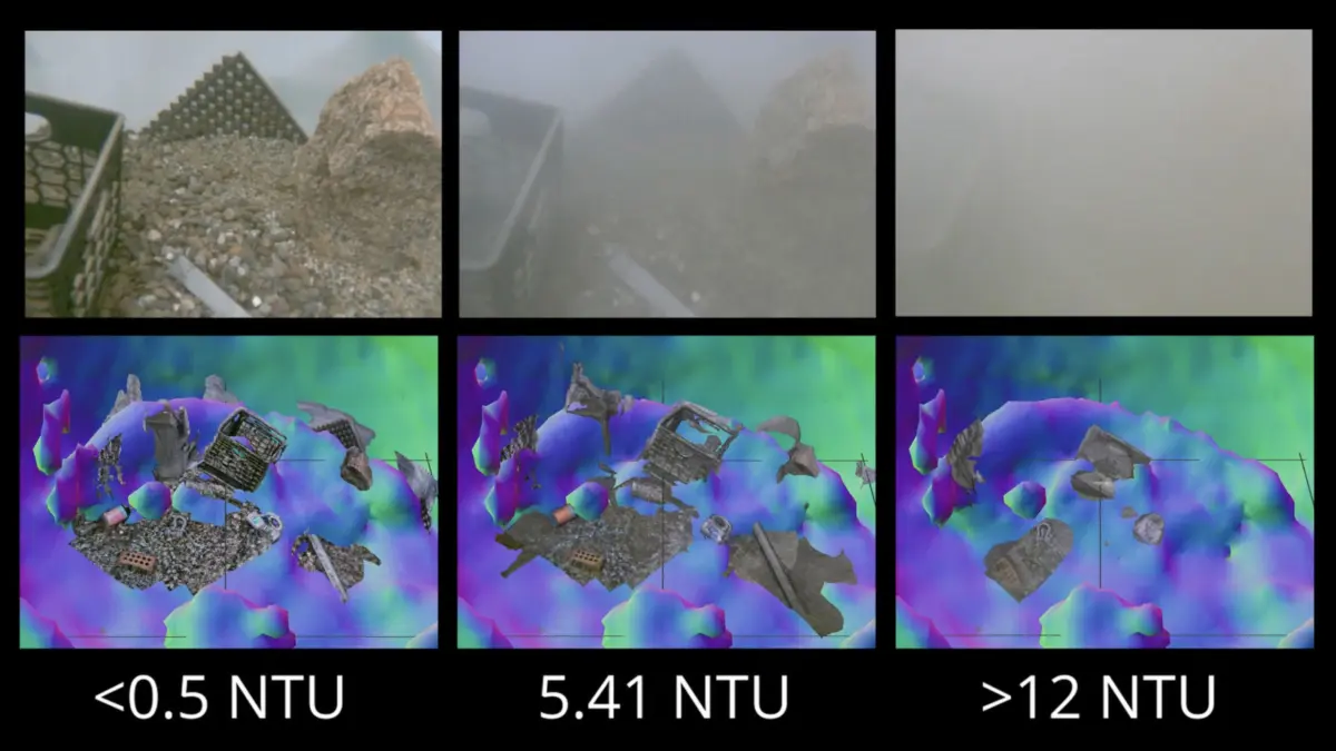
This technological leap is not merely an incremental upgrade to subsea sensors; it is a foundational shift in how machines interact with low-visibility aquatic environments. By translating rapid acoustic data into high-confidence spatial models on the fly, the system allows vehicles to bypass the waiting game, safely closing the distance to targets of interest even when optical visibility is zero. With sweeping implications for marine scientific discovery, deep-sea infrastructure maintenance, offshore renewable energy installation, and national security operations involving unexploded ordnance, this innovation promises to unlock unprecedented efficiency, safety, and precision across the global blue economy.
Detailed Chronology: From Subsea Blindness to Real-Time Acoustic Mapping
The Genesis of a Subsea Bottleneck
The limitations of underwater optical imaging have plagued oceanographers and marine engineers since the inception of crewed and uncrewed subsea exploration. Water absorbs and scatters light exponentially faster than air, restricting the effective range of standard cameras to mere meters under ideal conditions. When sediment is introduced into the water column—whether naturally via benthic currents or artificially via ROV thrusters—that scattering effect intensifies by orders of magnitude.
For years, the engineering community accepted this as an immutable law of oceanography. ROV pilots navigating complex subsea structures, such as deep-water blowout preventers or subsea manifolds, routinely experienced "whiteout" conditions. The standard operational protocol dictated a costly expenditure of time: back the vehicle away from the work zone, idle position-holding thrusters, and wait passively for particulates to drift back to the ocean floor. In commercial offshore operations, where vessel charter costs can easily exceed $100,000 per day, these enforced delays translate directly into millions of dollars in lost productivity.
Identifying the Acoustic Solution
Recognizing that optical systems alone could never overcome the physical realities of particulate scatter, Phung and Camilli began investigating how to exploit alternative regions of the electromagnetic and mechanical wave spectra. Sound waves, unlike light waves, propagate efficiently through water laden with suspended sediment. While sonar technologies have existed for a century, traditional acoustic systems present their own distinct operational trade-offs.
Standard multibeam or sidescan sonars provide exceptional range and penetrate turbidity effortlessly, but they traditionally suffer from low resolution compared to high-definition video feeds. Conversely, high-resolution optical cameras provide the exquisite detail required to manipulate delicate scientific samples or inspect micro-fractures in subsea welds, but they fail the moment the water turns murky.
The breakthrough came when the WHOI researchers hypothesized a multi-stage operational workflow: rather than using sonar and optics as competing technologies, they could be deployed sequentially in a closed-loop navigation feedback cycle.
Integrating Sonar with Advanced Image-Matching Algorithms
The core technical challenge in realizing this hybrid approach was computational latency. Traditional sonar processing pipelines are notoriously heavy, requiring significant computing power to construct three-dimensional point clouds from raw acoustic returns. In a dynamic subsea environment where an ROV may be drifting with underwater currents, post-processing sonar data ashore or in a slow onboard computer is useless for real-time collision avoidance and spatial orientation.
To solve this, Phung and Camilli integrated their acoustic hardware framework with a high-velocity image-matching algorithm originally developed by computer vision researchers in France. This specific algorithm was chosen for its mathematical elegance in rapidly estimating the relative depth of each individual pixel within a two-dimensional visual scene.
By feeding the acoustic data through this accelerated processing pipeline, the WHOI system transforms low-resolution sonar returns into actionable spatial awareness maps in real time. The vehicle’s onboard processing unit rapidly evaluates the surrounding topography, constructs a reliable spatial framework of obstacles and targets, and calculates a safe trajectory. This allows the robotic vehicle to safely bridge the perceptual gap—navigating blindly through the sediment cloud using acoustics, until it reaches a precise proximity where optical cameras can finally pierce the clearing water and capture high-resolution imagery.
Supporting Context & Metrics: The Physics and Economics of Subsea Operations
The Physics of Turbidity and Acoustic Propagation
To understand the significance of the WHOI breakthrough, one must examine the fundamental physics governing underwater sensor performance. Light attenuation in seawater is governed by absorption and scattering coefficients driven by colored dissolved organic matter (CDOM), phytoplankton, and inorganic suspended mineral particles. In high-turbidity zones—such as river mouths, deep-sea mud volcanoes, or construction sites disturbed by heavy trenching—the attenuation coefficient ($alpha$) spikes dramatically, reducing the beam attenuation length to less than 10 centimeters.
Acoustic systems operate on entirely different physical principles. Sound propagation underwater is defined by acoustic impedance, frequency, and spherical spreading losses. Lower-frequency acoustic waves (ranging from 100 kHz to over 1 MHz in imaging sonars) pass through suspended particulate matter virtually unhindered because the wavelength of the acoustic signal is orders of magnitude larger than the diameter of the silt or clay particles (typically 2 to 62 micrometers).
By leveraging this acoustic transparency, Phung and Camilli’s system bypasses the primary failure mode of optical machine vision. However, converting acoustic returns into real-time depth maps has historically required massive computational overhead. The French image-matching algorithm acts as a crucial computational catalyst, compressing the processing timeline from minutes or hours into milliseconds, thereby meeting the stringent latency requirements of closed-loop dynamic robotic control systems.
Economic and Operational Impact Metrics
The commercial and scientific implications of reducing subsea operational downtime are monumental. Consider the following structural metrics governing deep-water intervention:
- Vessel Operating Expenditures: High-spec dynamic positioning (DP Class 2 and Class 3) offshore support vessels (OSVs) command day rates ranging from $50,000 to well over $200,000 depending on regional market conditions and specialized equipment loadouts.
- Frequency of Sediment Disturbance: During routine subsea asset inspection, pipeline burial monitoring, and intervention tasks, ROV thrusters and tooling packages disturb bottom sediments in approximately 65% to 80% of shallow-to-moderate depth benthic operations, and routinely in soft-sediment deep-water provinces.
- Downtime Reductions: Traditional operations forced to wait for particulate settling lose an estimated 15% to 30% of total bottom-time to waiting periods. Implementing a real-time acoustic-visual hybrid navigation system recovers this lost productivity, potentially saving commercial operators millions of dollars annually per asset.
Official Statements & Expert Perspectives
The innovation has generated considerable interest within the marine robotics and ocean engineering communities, highlighting the practical utility and visionary nature of the research.
Dr. Richard Camilli contextualized the operational mechanics and intuitive safety margins of the new technology using a vivid terrestrial analogy:
"An analogy would be if you were to go into a china shop in the dark, and try to pick your way around to find a specific coffee mug without knocking things over. This would allow you to do that."
This metaphor powerfully illustrates the core breakthrough: the system does not simply give a robot a general sense of direction; it provides the granular spatial awareness necessary to operate with extreme delicacy inside confined, hazardous, and completely obscured environments.
Co-creator Amy Phung emphasized the broad utility of the technology across multiple distinct maritime sectors, noting that the underlying architecture was designed from the ground up to be adaptable to various vehicle classes and mission profiles. According to Phung and Camilli, the primary operational domains poised to benefit immediately from the technology include:
- Scientific Exploration: Unlocking benthic ecosystems, hydrothermal vent fields, and fragile deep-sea coral habitats without risking physical damage from uncontrolled vehicle drift or accidental contact caused by visibility loss.
- Underwater Construction and Maintenance: Streamlining complex subsea engineering tasks, such as mating hydraulic connectors, turning subsea valves, and inspecting structural welds on offshore oil and gas platforms or floating wind turbine anchors.
- Defense and Humanitarian Security: Enhancing the detection, identification, and handling of unexploded ordnance (UXO) and historical sea mines resting on sediment-heavy ocean floors, where traditional optical identification poses extreme risk to human explosive ordnance disposal (EOD) teams and autonomous systems alike.
Future Outlook: The Next Horizon in Autonomous Marine Robotics
As Phung and Camilli advance toward the culmination of their doctoral and research milestones at the Woods Hole Oceanographic Institution, the roadmap for this technology points toward broader commercial integration and advanced artificial intelligence coupling.
Integration with Autonomous Underwater Vehicles (AUVs)
While much of the initial testing and conceptual framework has focused on remotely operated vehicles tethered to surface support ships, the true scaling potential of the WHOI system lies in fully autonomous underwater vehicles (AUVs). Unlike ROVs, which benefit from human pilots interpreting telemetry and making split-second tactical decisions, AUVs must execute complex intervention and mapping tasks entirely unaided.
By equipping AUVs with real-time acoustic-visual depth-matching capabilities, future autonomous systems will be able to perform autonomous benthic docking, subsea infrastructure inspection, and environmental monitoring missions in high-turbidity waters without requiring human intervention or acoustic positioning base-stations. This capability will drastically lower the cost barrier for deep-sea data collection, enabling persistent, long-duration ocean observation networks that remain resilient against shifting coastal plumes, storm runoffs, and benthic sediment disturbances.
Machine Learning and Sensor Fusion Evolution
Looking further ahead, the research team anticipates integrating deep-learning neural networks trained specifically on multi-modal subsea datasets. By feeding historical acoustic-visual pairing data into machine-learning models, future iterations of the software will likely be able to anticipate turbidity patterns, predict structural topography before direct acoustic illumination, and optimize sensor sampling rates dynamically based on the specific mineral composition of the seafloor silt.
Conclusion
The ocean covers over 70% of the Earth’s surface, yet the vast majority of its benthic zones remain less mapped than the surface of Mars. For decades, our technological reach has stopped abruptly at the edge of visibility—stymied by the simple physical reality of stirred-up sand and silt. By bridging the gap between acoustic mapping and high-speed computer vision algorithms, Amy Phung and Dr. Richard Camilli at the Woods Hole Oceanographic Institution have provided the key to unlock these opaque environments. As this technology transitions from WHOI laboratories to commercial fleets and scientific vessels worldwide, it promises to redefine our operational boundaries, transforming the murky, unpredictable seafloor into an accessible, navigable frontier.